Case Study No. 14: Using drones to create maps and assess building damage in Ecuador
Discussion details
NATURAL DISASTER | MONITORING AND REAL TIME INFORMATION | ASSESSMENT
Type of system: Inspire 1 Pro; SkyRanger
Deploying Agency: GlobalMedic
Piloting Agency: AeroVision Canada, GlobalMedic
Dates of Deployment: April-May 2016
File: Download
A magnitude-7.8 earthquake struck Ecuador on 16 April 2016, causing over 660 deaths, thousands of injuries and widespread destruction across the north-west part of the country. The most severe damage was concentrated in the provinces of Manabí and Esmeraldas along the northern coastline. In response, the Ecuadorian Army and AeroVison carried out missions every day, using drones to assess the level of damage in cities and towns and producing maps to determine priority areas of intervention to support shelter reconstruction.
Background
After the worst earthquake in 40 years hit Ecuador, a state of emergency was declared in the six coastal provinces. In the especially hard-hit city of Pedernales, in Manabí province, a state of disaster was declared. Rescue operations and the search for survivors began immediately after the earthquake and continued for several days. Thousands of people were left homeless, with homes either damaged or completely destroyed. Experts estimate it will take years for the hardest hit areas to recover and that rebuilding will cost up to €2.6 billion (US $3 billion).[1]
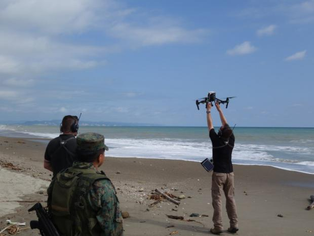
Aerovision drone pilot launching a Phantom 1 pro. Photo: Aerovision
To support the response, several private sector drone pilots deployed to Ecuador in the days following the earthquake. AeroVision Canada, a professional unmanned aerial vehicle operator, partnered with the charity GlobalMedic to support Ecuador’s National Secretariat for Risk Management by capturing aerial imagery, developing maps and helping assess the damage in some of the worst-affected regions.
AeroVision further piloted their drones together with the Ecuadorian Army to develop maps and carry out aerial imaging in support of recovery activities, such as rapid assessments of buildings. From mid-April to early May, AeroVision mapped 800 acres (about 3.2 km²) of dense residential areas in four cities, for which only outdated paper maps existed. They also used their drones to assess commercial and private structures in order to help decision makers prioritize actions.
GlobalMedic meanwhile used their own trained pilots to produce 2D maps for the National Secretariat for Risk Management to assess damage.
Implementation
As soon as the earthquake struck, numerous humanitarian organizations such as GlobalMedic deployed to the region to support the response. GlobalMedic has a track record of using drones in emergency operations and considers drones a part of their emergency response toolkit.[2] Several of their volunteers had been trained as drone pilots by Aeryon Labs, a company that manufactures the SkyRanger and other drones.
Just over a week after the earthquake, GlobalMedic teams had mapped more than 5 km² near Canoa and San Vincente, covering areas where roads were blocked due to landslides. By the end of April, GlobalMedic teams were flying an Aeryon SkyRanger, on a daily basis around Manta, Pedernales, Portoviejo and San Vincente in the Manabí province.[3] Working with the National Secretariat for Risk Management, GlobalMedic’s drone team collected information obtained by SkyRangers and produced 2D maps to help assess the damage in the worst-affected regions. The SkyRanger can fly up to 50 minutes and as far as 5 km from the pilot. It is equipped with a 16-megapixel still camera that can also take high definition video.
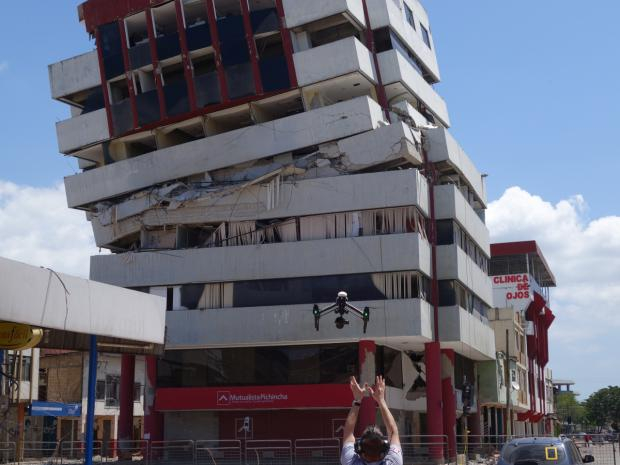
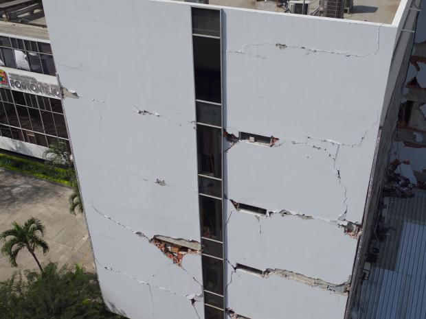
Photo: Aerovision
Several other private companies volunteered pilots and equipment to fly mapping missions in support of GlobalMedic and in coordination with the UAViators network. AeroVision deployed a drone pilot and engineer along with two Inspire 1 Pro drones, which can fly up to 5 km from their pilot and are designed for aerial imaging. The drones were used with 16-megapixel micro four thirds cameras with a ground sample distance of 2-3 centimetres. Although this drone could also be flown with a thermal camera, AeroVision was not able to transport such a camera from Canada through the United States due to restrictions related to the military grade quality of the equipment.[4] As the tasks in Ecuador consisted of mapping and aerial imaging, thermal cameras were not necessary for this deployment.
The data were uploaded to an online cloud-based system and made into maps with the web application Maps Made Easy. Because of the humanitarian nature of the deployment, Maps Made Easy provided additional assistance and support, expedited the maps and donated the production costs of Digital Elevation Models (DEMs) and ortho-mosaics. Maps were usually provided the day after a flight; on some occasions, maps were completed within 12 hours.
An earthquake-damaged building from a bird’s eye view, taken with the Phantom 1 pro. Photo: Aerovision
Approval to fly the drones was granted by local authorities at the provincial level. The initial support by GlobalMedic enabled AeroVision to easily enter Ecuador with their equipment. Information sharing was also relatively easy, because AeroVision was either working directly with GlobalMedic or with the military, sharing information products as they were made available, in close collaboration with the relevant actors on the ground. “There was nothing done that wasn’t communicated to the officers from the Risk Analysis Secretariat and with the military counterparts,” said AeroVision’s Trevor Bergmann, when asked about information sharing.
Not long after arriving in Ecuador, AeroVision concluded that providing full-time support to conduct evaluations together with the military would be a good use of their time. They began to work in close partnership with the military as they carried out assessments throughout the affected area and soon were considered an integral part of the assessment teams. According to Mr Bergman, at first, the government and military actors were not entirely sure what they were looking for from drone operators, but as soon as they were able to see what the Inspire 1 Pro could do, they requested AeroVision to accompany them on each assessment.
On a daily basis, the Army and AeroVison drones and pilots assessed damage in cities and towns and produced maps that helped the Army to make decisions on priority response areas. The drones were able to expedite the decision-making process, according to Bergmann, who highlighted how the drones were able to capture images faster than if a team was deployed to an area. “It also kept teams safe from dangerous buildings by evaluating their structures using the drones,” said Mr Bergmann. A structural engineer from AeroVision provided estimates based on the visuals to help determine the stability of buildings damaged by the earthquake.
Evaluation
Choice of Method
The enthusiasm with which the government accepted and adopted the use of drones indicates how useful these tools were as part of the overall response. It added value because it saved time, enhanced safety and provided higher quality data than other methods, such as ground-based visual assessments alone. The response was improved because important information and coordination tools – 2D and 3D maps and DEMs – were provided faster and were of higher quality than ground-based visual assessments.
Drones were perceived to have made shelter assessments easier. This influenced which areas were prioritized for intervention. It remains unknown whether or not this made an impact in the provision of shelter materials or the completion of formal shelter assessments, but it does provide insight into how certain shelters were prioritized, depoliticizing the process to an extent. If ever there was a question as to why the Army intervened in one area compared to another, there was data collected by drones to back up their response.
Community Engagement and Social Acceptance
When it came to liaising and interacting with the communities, AeroVision reported “nothing but support.” Whenever Bergmann and his team deployed, they took time to talk to people. Community members could a view the live feed, ask questions and even show others an aerial view of their houses. This was done in an ad hoc fashion, but anecdotally appeared to be a positive method to ensure drone flights were well received by communities.
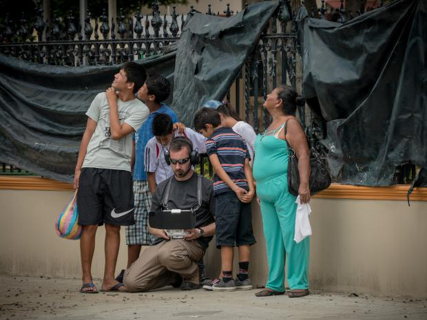
Photo: Aerovision
Plans for Adaptation
The government reported to AeroVision that they would be amenable to continuing to work with drone counterparts, both technical materials and skilled experts, but only on a pro bono basis. AeroVision expressed its continued interest to deploy for humanitarian response missions like this one. GlobalMedic has been using drones for more than six years as part of their disaster response toolkit and plans to continue to do so.
Resources
- Global News: AeroVision Canada, a Halifax based drone company is back from mapping the epicenter of the earthquake in Ecuador: http://globalnews.ca/video/2705664/aerovision-ecuador/
- CBC News: Bedford company sending drones to survey earthquake damage in Ecuador: http://www.cbc.ca/news/canada/nova-scotia/disaster-relief-drones-in-ecuador-1.3560002
- CBC News: How a Canadian team’s drones are changing search and rescue: https://www.thestar.com/news/world/2016/05/02/how-a-canadian-teams-drones-are-changing-search-and-rescue.html
Endnotes
[1] As quake toll rises, Ecuador vows to rebuild: http://www.latimes.com/world/mexico-americas/la-fg-ecuador-earthquake-20160419-story.html
[2]How a Canadian team’s drones are changing search and rescue: https://www.thestar.com/news/world/2016/05/02/how-a-canadian-teams-drones-are-changing-search-and-rescue.html
[3] http://reliefweb.int/report/ecuador/globalmedic-scales-uav-wash-response-earthquake-affected-ecuador
[4] http://www.infraredcamerasinc.com/thermal-infrared-resources/shipping-export-restrictions/
Drones in Humanitarian Action is partially funded by DG ECHO. This case study covers humanitarian aid activities implemented with the financial assistance of the European Union. The views expressed herein should not be taken, in any way, to reflect the official opinion of the European Union, and the European Commission is not responsible for any use that may be made of the information it contains.

Log in with your EU Login account to post or comment on the platform.