
PVGIS - Photovoltaic Geographical Information System
Photovoltaic Geographical Information System (PVGIS)
Geographical Assessment of Solar Resource and Performance of Photovoltaic Technology
| [ibimage==33538==original==http://re.jrc.ec.europa.eu/pvgis/apps4/pvest.php?map=africa==_blank====] |
Image
|
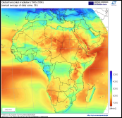
Interactive access to solar resource and photovoltaic potential (click on the maps)
The maps represent yearly average of daily total of global irradiation on a horizontal and/or optimally inclined surface. The data are derived by resolution enhancement of the HelioClim-1 database, representing 20-years average of the period 1985-2004 [kWh/m2].
| IMPORTANT |
| The maps are free for public use, their reproduction is authorised provided the source is acknowledged: |
|
PVGIS © European Communities, 2001-2008 HelioClim-1 © MINES ParisTech, Centre Energetique et Procedes, 2001-2008 In case that you include any of these maps in your publications, please cite this reference: For further information please consult the PVGIS website: http://re.jrc.ec.europa.eu/pvgis/cmaps/afr.htm Last update: 01-07-2016 Contact: Thomas Huld (JRC C.2) |