Case Study No. 13: Using drones to inspect post-earthquake road damage in Ecuador
Discussion details
NATURAL DISASTER | MONITORING AND REAL TIME INFORMATION | ASSESSMENT
Type of system:Phantom 3 Pro, Inspire 1, eBee
Deploying Agency:UAViators
Piloting Agency:UAViators
Dates of Deployment: April 2016
In April 2016, a magnitude-7.8 earthquake struck north-west Ecuador, damaging homes, buildings and infrastructure and killing more than 660 people. Thousands of buildings and homes were damaged or destroyed, as well as other infrastructure such as roadways and bridges. The earthquake caused soil to shift, increasing the risk of landslides during the 189 aftershocks that were counted in the two days after the quake.[1] To have a clearer picture of how the land had moved and to assess further risk of landslides, drones were provided to the government to collect data to develop ortho-mosaics and maps that helped geologists and project managers assess risk and make decisions.
Background
After the worst earthquake in 40 years hit Ecuador, a state of emergency was declared in the six coastal provinces – Esmeraldas, Galapagos, Guayas, Los Rios, Manabí and Santo Domingo. Rescue operations and the search for survivors began immediately after the earthquake and continued for several days. Thousands of people were left homeless, and experts estimate it will take years for the hardest hit areas to recover and rebuild. Within a day, numerous humanitarian organizations had begun to respond to the needs on the ground. Among them were volunteer drone pilots (with 10-12 drones among them) who collaborated with government and non-government actors to gain a better understanding of the situation from above and to inform the response.
Local entrepreneur and engineer Francisco Ruiz was one of those volunteer drone pilots. Mr Ruiz worked with and as part of a UAViators roster of pilots alongside local government authorities by flying drones to collect data in the affected areas.
In particular, Mr Ruiz and other volunteers supported aerial surveys for the Ministry of Transport in several areas across Manabí. They were able to analyse and publish data less than three days after the earthquake, providing maps with the most up-to-date information available. Mr Ruiz and his collaborators provided aerial data that was shared on a public geo-portal platform run by OpenAerialMap[2] (affiliated with OpenStreetMap). Because of the speed with which they were able to collect and disseminate the data, these outputs were critical tools for decision makers and other authorities in the days and weeks following the disaster.
Implementation
According to Carola Gordillo, a Quality Control Manager with the Ministry of Transport based in Manabí, the data from the drones were collected and analysed with the help of geologists to get a clearer picture of the overall post-quake situation. She highlighted that it was critical that the government assess the roads to understand the damage. She emphasized that it was equally important to assess areas surrounding the roads, including hillsides and slopes, to understand the damage and to prioritize the response. Ms Gordillo and her colleagues accompanied many of the drone flights in Manabí, and were able to cover 1 000 kilometres of roadways in three weeks.
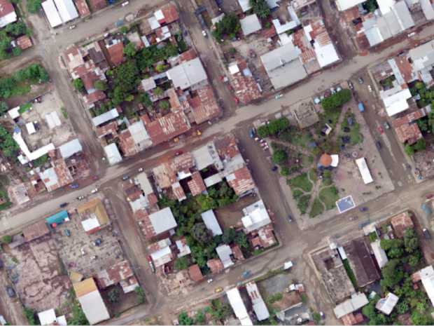
An aerial image captured by an Inspire 1 drone showing damage caused by the earthquake. Photo: Francisco Ruiz
The drones flown by Francisco Ruiz and other pilots who took part in the response included two quadcopters – the DJI Phantom 3 Professional and DJI Inspire 1 – and several fixed-wing eBees. The Phantom 3 can fly for 23 minutes and up to 5 km away from its pilot. It can livestream and take videos and still images. The Inspire can fly for 15 minutes and up to 5 km from its pilot and is also able to provide imagery in real time. Both the Inspire 1 and Phantom 3 Professional take images with a resolution ranging from 6 to 10 cm ground sampling distance (GSD). The eBee is a fixed-wing craft and able to cover 12 km² in one flight, with a flying time of about 50 minutes. The eBee possesses an 18.2 megapixel resolution camera with a 1.5 centimetre GSD, and is a widely used mapping drone. Typically, a team of two to three people conducted a mission together, with one pilot and at least one observer.
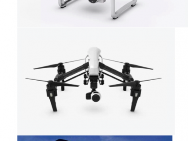
The Phantom 3 pro and Inspire 1 made by Dji. The eBee, made by Sensefly.
Because of the close collaboration with the government, it was easy for drone pilots to support the emergency response. Immediately after the earthquake, drone pilots asked the government’s emergency response authority, the National Secretariat for Risk Management (SNGR), how to gain authorization to fly. The SNGR decided that approval for drone flights would be granted by local authorities. Since the drones were requested by the authorities and used alongside them, there were no reported issues with authorization.
When it came to liaising with local communities, the drone operators and government authorities ensured that they communicated with communities whenever possible when flying. Drone operators and their government partners discussed their activities in the field to gain a clearer understanding of how communities felt about the drones. Typically, communities were neutral or provided positive feedback.
Evaluation
Drones were able to rapidly assist the government largely because drones were already on the ground prior to the earthquake, and drone pilots had already been trained through UAViators and other organizations on the use of drones in humanitarian response operations. Because the drone pilots were already close to the affected area and had the capacity to support, it was easy to initiate a response as soon as the quake struck.
The value of their presence and training continued to be useful as the days and weeks passed and government decision makers used the maps as well as the data collected to assess the risk of future soil movement onto roadways. The drone as a tool was easily integrated into the general assessment toolkit at the Ministry of Transport, according to Gordillo.
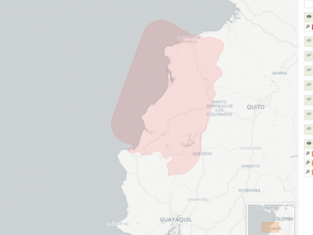
OpenAerialMap image of the earthquake affected area and locations where drones collected information.
“With drones, you could go beyond just the roadways and see the diagnosis [of damage] more clearly,” Ms Gordilla said. “It allowed us to go to higher risk areas. Not so much risk in terms of danger, but more so in terms of time and space; areas that are hard to reach and more remote.”
As the drones collected more data and more maps and ortho-mosaics were created, the government saw the breadth of possibility that these tools have. When asked about the impact that drones had in decision-making, Ms Gordilla said that “with these tools you get a formal justification as to why an area is in need. You get proof of the need and you can use that proof to support your decision to prioritize that area.” She noted that it was not just a tool for her as a decision maker, but it was also useful to justify her conclusions to her supervisors.
Mr Ruiz and other drone pilots coordinated deployments and avoided duplication by using the messaging application WhatsApp to discuss launch times and locations. “Because of the large area and because we were using WhatsApp it was not difficult to cover a few dozen hectares each day,” Mr Ruiz said. Lists of deployment locations and times were updated with each mission flown and shared on a common Google Drive.
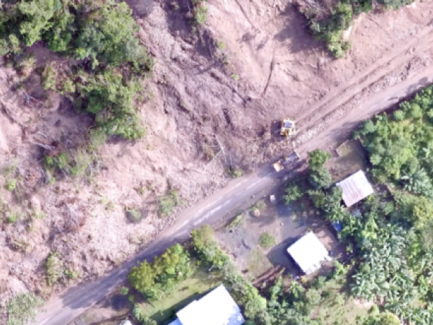
Drone image of a landslide that caused roadway damage following the earthquake. Photo: Francisco Ruiz
The Inspire 1 was a favourite of drone pilots, according to Ruiz, because it can be flown manually and “obeys” the pilot well. However, a fixed-wing drone like the eBee has the added value that it can cover more ground. The take-offs and landings of the eBee made them a little more challenging to pilot, mainly because some of the surface areas, such as rubble or thick underbrush, were not ideal for landing this type of drone. The operating environment in many areas consisted of dense forests, which made it difficult at times to observe the drone’s pathway. This is also why it was so important to pilot them in teams.
The Ministry of Transport does not have any plans to purchase drones, but did express a great interest in continuing to use them in partnership with universities and others. They emphasized that if they could continue to benefit from the use of drones through partners, though would do so.
Author: Jessica DuPlessis
Resources
- Watch: Buildings destroyed and roads torn up in Ecuador earthquake aftermath: http://www.telegraph.co.uk/news/2016/04/18/watch-buildings-destroyed-and-roads-torn-up-in-ecuador-earthquak/
- Road Damage in Manabí: http://www.eqclearinghouse.org/2016-04-16-muisne/2016/05/06/road-damage-in-manabi/
Endnotes
[1] IFRC Emergency plan of Action, Ecuador: Earthquake, 16 April 2016.
[2] https://beta.openaerialmap.org/#/-80.211181640625,-0.7223319390984623,9?resolution=high&_k=50xdek

Drones in Humanitarian Action is partially funded by DG ECHO. This case study covers humanitarian aid activities implemented with the financial assistance of the European Union. The views expressed herein should not be taken, in any way, to reflect the official opinion of the European Union, and the European Commission is not responsible for any use that may be made of the information it contains.

Log in with your EU Login account to post or comment on the platform.