Library
Photo gallery
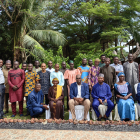
Project photos
Nigeria
Energy
Electrical transmission/ distribution
Energy access
+4Energy research
Energy security
Regional energy markets
Renewable energy
Project photos
La exposición nos invita a observar el planeta Tierra a través de los ojos de los satélites centinelas de Copernicus. Espectaculares imágenes de varios lugares alrededor de Europa y de Panamá capturan la belleza y la fragilidad de...
ESS Cycle of conferences 12 March 2019: Slides 1 - GEF - Improving international development evaluation through geospatial data and analysis (Dr. Geeta Batra and Dr. Anupam Anand)
ESS cycle of conferences: Slides 2 - DEval - Improving international development evaluation through geospatial data analysis - Lessons learned from DEval‘s enhanced land-use planning evaluation
ESS cycle of conferences 12 march 2019: Slides 3 - Copernicus: full, free and open EO data and information
Presentation slides for the first conference: IFAD-CRRC presentation - Combining satellite imagery with traditional evaluation techniques - The evaluation of IFAD’s Agricultural Support Project in Georgia

Explore TRANSrisk through these informative infographics. Visit our website for interactive version. http://www.transrisk-project.eu/consensus-building/infographics
Explore TRANSrisk through these informative infographics. Visit our website for interactive version. http://www.transrisk-project.eu/consensus-building/infographics
TRANSrisk partner Stockholm Environment Institute (SEI) has developed an interesting discussion brief which presents the TRANSrisk case study in Kenya. The brief examines fundamental questions about development priorities and...
In our latest press release the TRANSrisk case study in Greece is demontstrated.